


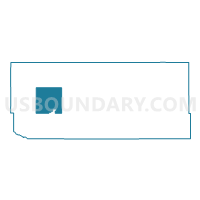
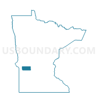
Moyer Twp. Voting District, Swift County, Minnesota
About
Outline

Summary
| Unique Area Identifier | 604612 |
| Name | Moyer Twp. Voting District |
| County | Swift County |
| State | Minnesota |
| Area (square miles) | 34.75 |
| Land Area (square miles) | 34.65 |
| Water Area (square miles) | 0.10 |
| % of Land Area | 99.70 |
| % of Water Area | 0.30 |
| Latitude of the Internal Point | 45.29001600 |
| Longtitude of the Internal Point | -95.94287210 |
Maps

Graphs
Select a template below for downloading or customizing gragh for Moyer Twp. Voting District, Swift County, Minnesota


Neighbors
Neighoring Voting District (by Name) Neighboring Voting District on the Map
- Appleton Twp. Voting District, Swift County, MN
- Edison Twp. Voting District, Swift County, MN
- Fairfield Twp. Voting District, Swift County, MN
- Hegbert Twp. Voting District, Swift County, MN
- Holloway Voting District, Swift County, MN
- Marysland Twp. Voting District, Swift County, MN
- Shible Twp. Voting District, Swift County, MN
- Tara Twp. Voting District, Swift County, MN
Top 10 Neighboring County Subdivision (by Population) Neighboring County Subdivision on the Map
- Appleton township, Swift County, MN (203)
- Fairfield township, Swift County, MN (128)
- Shible township, Swift County, MN (124)
- Edison township, Swift County, MN (106)
- Marysland township, Swift County, MN (96)
- Hegbert township, Swift County, MN (93)
- Holloway city, Swift County, MN (92)
- Moyer township, Swift County, MN (88)
- Tara township, Swift County, MN (88)